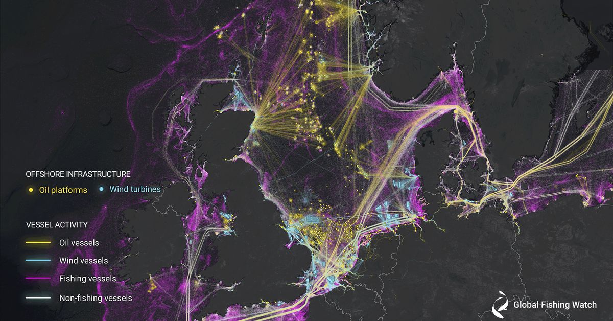
The effort exposed a huge amount of industrial activity that previously flew under the radar, from suspicious fishing operations to an explosion of offshore energy development.
Until now, Global Fishing Watch and other organizations relied primarily on the maritime Automatic Identification System (AIS) to see what was happening at sea.
Since 2,000 terabytes is an enormous amount of data to crunch, the researchers developed three deep-learning models to classify each detected vessels, estimate their size, and sort out different kinds of offshore infrastructure.
In the Northeast US, clean energy opponents have tried to falsely link whale deaths to upcoming offshore wind development even though evidence points to vessel strikes being the problem.
“Until now, no comprehensive, global map of these different types of maritime infrastructure had been available,” says the article written by Microsoft postdoctoral researcher Konstantin Klemmer and University of Colorado Boulder assistant professor Esther Rolf.
“The reason this matters is because it’s getting more crowded [at sea] and it’s getting more used and suddenly you have to decide how we’re going to manage this giant global commons,” Kroodsma tells The Verge.
The original article contains 874 words, the summary contains 183 words. Saved 79%. I’m a bot and I’m open source!

This is the best summary I could come up with:
The effort exposed a huge amount of industrial activity that previously flew under the radar, from suspicious fishing operations to an explosion of offshore energy development.
Until now, Global Fishing Watch and other organizations relied primarily on the maritime Automatic Identification System (AIS) to see what was happening at sea.
Since 2,000 terabytes is an enormous amount of data to crunch, the researchers developed three deep-learning models to classify each detected vessels, estimate their size, and sort out different kinds of offshore infrastructure.
In the Northeast US, clean energy opponents have tried to falsely link whale deaths to upcoming offshore wind development even though evidence points to vessel strikes being the problem.
“Until now, no comprehensive, global map of these different types of maritime infrastructure had been available,” says the article written by Microsoft postdoctoral researcher Konstantin Klemmer and University of Colorado Boulder assistant professor Esther Rolf.
“The reason this matters is because it’s getting more crowded [at sea] and it’s getting more used and suddenly you have to decide how we’re going to manage this giant global commons,” Kroodsma tells The Verge.
The original article contains 874 words, the summary contains 183 words. Saved 79%. I’m a bot and I’m open source!
Good bot!